How it started
In February 1971, Douglas Knapp, the Rideau Trail Association’s first Treasurer, proposed a hiking trail in the rugged Canadian Shield north of Kingston during a meeting of the Kingston Field Naturalists – a concept that was expanded to form a walking trail that would connect Kingston and Ottawa.
A like-minded group in Ottawa got involved and the offspring of these two groups was named after the Rideau Canal waterway that had linked the two cities since 1832. Thus the Rideau Trail was born.
Construction of the Trail
The trail was to be constructed by volunteers over a period of five years but in March of 1971, a group of university students heard of the plans and successfully proposed to complete building the trail during one summer with the support of an Opportunities for Youth grant through the federal government. Routes and Negotiation committees were quickly set up in Ottawa, Smiths Falls and Kingston and by mid-May, the 27-member student group began construction of the trail as the Routes and Negotiation committees worked to keep ahead of them. By June, enough trail had already been built to permit an inaugural hike in the Gould Lake Conservation Area, 30 km north of Kingston. By the end of August, a continuous trail was established from Kingston to Ottawa.
Official Opening
In November 1971, an official Trail opening was held at the Foley Mountain Conservation Area north of Westport, attracting an audience of about 200 supporters. The ceremony was performed by the Rt. Hon. John Davies, Federal Minister of the Environment and the Hon. James Auld, Ontario Minister of Tourism and Information. At that time, the Rideau Trail Association had about 250 members. Join the Rideau Trail Association today!
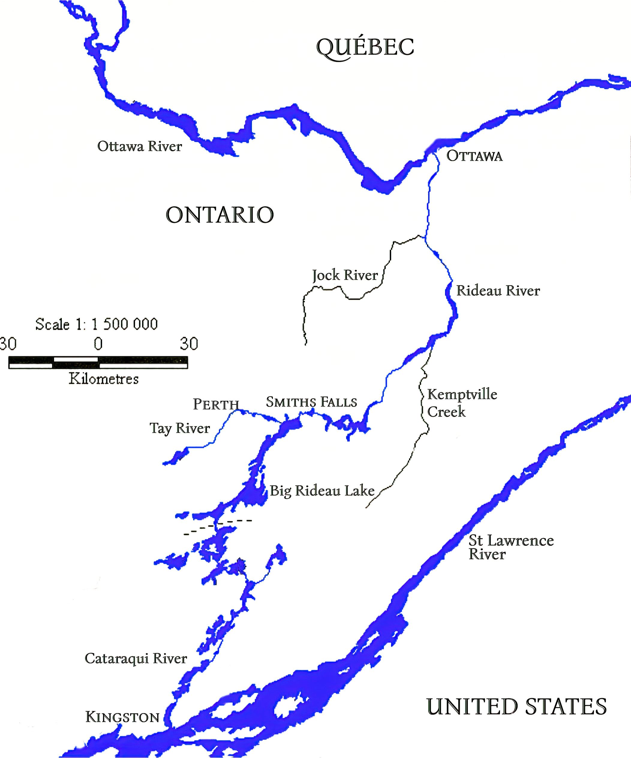
About the Trail
The main trail itself crosses terrain ranging from placid farmland to the rugged Canadian Shield. It is intended for hiking, snowshoeing, and cross-country skiing. The Rideau Trail Association does not own any of the lands that the trails go through and the continuity of the trails is made possible by the generous permission of both private and public landowners and enhanced by a special fund called the Rideau Trail Preservation Fund.
Each of the three hiking clubs of the RTA – Kingston, Central and Ottawa, organize outings year-round. Outings take place throughout the week (usually a great emphasis on weekends) and can include cross-country skiing and snowshoeing in the winter and hiking, cycling and paddling in the spring, summer and fall.
Maps and trail descriptions are available free to both members and non-members on the website.
On the main Rideau Trail, red-orange isosceles triangles mark the northbound route to Ottawa while red-orange triangles with yellow tips mark the southbound route to Kingston. In addition to the main trail (approximately 325 km long), there are a number of connectors, loops and side trails which are marked by blue triangles. The total length of cleared and marked trails that make up the Rideau Trail network is over 450 km. Discover the trail!
Getting to Know the RT Region
For thousands of years Indigenous peoples have lived in the Rideau River watershed area between Kingston and Ottawa. For the last several centuries, they have been members of the Algonquin nation in the Northern two-thirds of the area. They speak the Algonquin language, which is part of the Algonquian language family. Culturally and linguistically, they are closely related to the Odawa, Potawatomi, Ojibwe (including Oji-Cree), Mississauga and Nipissing, with whom they form the larger Anicinàpe (Anishinaabeg). In the Southern portion of the area the Huron Wendat were the dominant peoples over 500 years ago. There were ongoing hostilities between the Iroquoian Wyandot and the Haudenosaunee, another Iroquoian confederacy, however the Wyandot had good relations with the Algonquian. Due to losses from fighting and from disease (primarily ones brought into the area by Europeans) the Wyandot migrated West and South and the Anishinaabe peoples became the dominant group.
These were self-sustaining societies who cultivated corn, sunflower, and other crops and supplemented their diet with hunting and fishing. The Indigenous peoples were skilled in making and using canoes and traded widely (initially with each other and then with the explorers and settlers). Although this occasionally led to conflict, more often treaties were negotiated and agreed. One of the more well-known treaties was based upon the concept of “one bowl, many spoons”. This concept acknowledged that the land and all of its resources are the one bowl and all peoples must share the resources available.
The Algonquin people first submitted a petition to the Crown in 1772 to establish a treaty relationship but unfortunately efforts were not successful until recent years. Currently, the Algonquins of Ontario are negotiating a land claim or modern treaty with Ontario and Canada on behalf of Pikwakanagan First Nation and the Algonquin communities of Antoine, Bonnechere, Greater Golden Lake, Kijicho Manitou Madaouskarini, Mattawa/North Bay, Ottawa, Shabot Obaadjiwan, Snimikobi and Whitney. Sections of the Rideau trail will likely be included in the treaty territory.
The arrival of explorers and settlers in this area, beginning with Champlain in 1603, greatly affected the Indigenous peoples living in the region. The waterways in the region were the high speed travel routes, as otherwise travel was on foot (snowshoes and sleds in the winter). The primary East – West route was along the (now named) Ottawa River from Montreal across to Lake Huron.
North – South travel made use of all of the plentiful rivers and lakes. Two key rivers were the Rideau River, which flowed North from Big Rideau Lake and emptied into the Ottawa River (a couple of waterfalls). The Anishinàbemowin name for the river is “Pasapkedjinawong”, meaning “the river that passes between the rocks.” The river was given the name “Rideau” (curtain) by the French because of the appearance of the Rideau Falls (explained in writing by Samuel de Champlain in 1613). The Cataraqui River forms the lower portion of the Rideau Canal and drains into Lake Ontario (very near the mouth of the St Lawrence River) at Kingston, Ontario. Prior to the Rideau Canal being built (1826 – 1832), the Cataraqui River had its headwaters in Dog and Loughborough lakes. It was a meandering creek that contained a great number of rapids and areas where portages were necessary. Today the watershed of the Cataraqui River includes lakes south of the watershed divide at Newboro; such as Sand, Opinicon, Clear and Newboro. Water from those lakes originally flowed into the White Fish River which drained to the Gananoque River rather than the Cataraqui River. This changed when a mill dam was built at White Fish Falls, near today’s village of Morton, as that dam retarded the outflow of the White Fish River to the Gananoque River, backed it up over the Cranberry Flood Plain, sending water south to the Cataraqui River. When the Rideau Canal was built (1826-1832), Haskins’ dam at Morton was enlarged and a new dam was built at Upper Brewers. Those two dams created Whitefish Lake, Little Cranberry Lake and much expanded Cranberry and Dog lakes. Most of the flow from what was previously the White Fish River watershed now flows down the Cataraqui River.
The construction of the Rideau Canal was a mammoth undertaking, creating a navigable waterway between the Ottawa River and Kingston through what was at the time a wilderness of rough bush, swamps and rock terrain. Led by Lieutenant-Colonel John By of the Royal Engineers, the Canal was constructed by thousands of labourers and tradesmen (carpenters, blacksmiths, stone masons, etc.), hired by independent contractors. All the work was done by hand with the aid of a few draft animals (oxen and horses). Most of the excavations were carried out by men with shovels, pickaxes and wheelbarrows. Much of the skilled rock work was done by experienced French Canadians, while the unskilled labour was generally made up of Irish immigrants and French Canadians. Some of the Irish labourers brought their families to the work sites, building rough shanty cabins. Others left their families in the newly created Bytown or the more established town of Kingston. There were deaths during construction, mostly from disease and the biggest culprit was malaria. By spring of 1832, the 202 km waterway was completed. Learn more about the Rideau Canal and its construction.
Statement of Acknowledgement
The Rideau Trail Association acknowledges and appreciates that the Trail passes through lands that the Indigenous Peoples have inhabited and protected for thousands of years and that these lands were the traditional lands of the Algonquin, Huron Wendat, Anishinaabe and Haudenosaunee peoples.